Due to a failure of a finish block which gave an grossly erroneous time from control 179 to the finish a decision was made to exclude the time for that leg from all courses that had that control (i.e. all but yellow and orange).
Safety Information
The competition area is predominately between 300m and 400m altitude, and very exposed. The weather can be very unpredictable.
Whistles will be compulsory. It will also be compulsory to carry or wear a taped-seam, hooded water-proof top.
Shorts are allowed. If conditions are poor, overtrousers may also be required at the organiser's discretion. There will be notices at assemby to notify you if you are required to carry or wear these.
If retiring during the race please only head for the Finish, which will be staffed. Moughton, the southern part of the area used by the longer courses, is surrounded by quarries on the east side and steep crags on the southern and western sides. There are a few paths down into Crummackdale, to the west, but it is a long way to any road or accommodation, as well being very distant from the Assembly area. A descent into Crummackdale is not recommended.
If you have any medical condition that you think we should be aware of please write this information down and seal it in an envelope with your name on and hand it in at registration. It will only be opened in case of emergency and will be destroyed afterwards if you do not recover it from us.
For anyone orienteering for the first time be aware that 'Course Closes Time' means that you should be back at the Finish by that time, and then proceed as fast as possible to Download in order for us to know that you have finished safely. Please do not forget to do that otherwise we will have to instigate a search which may involve us calling out Mountain Rescue needlessly.
First on the scene advice
1. We recommend that competitors carry a mobile phone.
2. If you hurt yourself and are mobile and require first aid – report to one of the first aid points marked on the map, or at assembly.
3. If you hurt yourself and are immobile – put on your rain top and get into a sheltered position if possible. If you have a phone ring the Organiser (number on the map),who will arrange for a first aider to attend. If no signal send a text. Or blow your whistle (six short blows, then pause for a minute) to get help.
4. If you encounter another competitor who needs help. Stay safe, and put on your rain tops. Carry out an appraisal of the injury, name of competitor and whether you can assist them to a first aid point. If immobile and you have a phone, let the organiser know location and whether assistance is required. Summon help as in Para 3. If you have to leave them to get help, make the casualty comfortable, make a note of the location, and go to the nearest first aid point printed on the map to Summon help
For runners from the Far Start, the 1st Aid point at the Far Start will remain active until 13.00. The 1st aid point at Sulber Gate will be withdrawn at 14.00. Thereafter 1st Aid will be available at the Finish until 14.30, and at assembly thereafter.
Directions / Parking
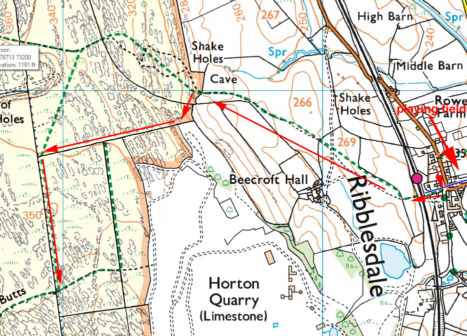
Parking and Assembly will be at Horton Playing Fields. This is located at the north side of the village, adjacent to the B6479. O signs will only be displayed at this entrance.
The car park field opens at 9.15.
There will be a £3 parking fee. Please have cash ready.
Unlike many minor Dales roads the B6479 is a generously wide road, other than in Horton village itself.
Please drive particularly carefully as you approach assembly. You may encounter fellow competitors walking on the pavementless road for 120m between Horton Rail Station and Assembly
There are trains arriving from and departing in the direction of both Carlisle and Leeds which would be convenient for the event.
Assembly
There will be a cake stall provided by the Aire Junior Squad. Please support them.
Portaloos will be provided.
Registration & Start Times
Registration, Enquiries and Download will be in the Pavilion at Assembly.
Registration will open at 9.30 until 11.30 (to allow for the longer than usual walks to the Starts)
Start times are from 10.30 to 12.30.
Courses close at 14.30. Controls will be collected in progressively from 13.00
Competitors will have set start times which you should try and keep to. They are designed to try and avoid queues in what are quite exposed start locations. However we appreciate it is not easy to predict the time it will take to get to either start. The start team have been advised to be flexible to avoid queues, particularly if the weather is bad. No-one will be penalised for arriving at the start late, although you may have to wait a little longer to start.
All competitors should punch at the Start and Finish. Those with hired SI cards should also punch at all controls.
There is a substantial walk to the starts. Both are remote from any driveable track. Please do not leave any water bottles or other litter at the starts. The start teams do not have the capacity to remove them.
Far Start: 2.65k 135m climb. Allow 45 minutes (the time taken by an M75)
Near Start 1.55k 105m climb. Allow 25 minutes (the time taken by an M75)
There is a Clothing Dump in an old walled sheep pen shortly before the Near Start. It is also en route to the Far Start.
The route to the starts crosses the footbridge at Horton Rail Station and then follows the main Sulber/3 Peaks path towards Ingleborough. This path is very distinct and will not be way-marked until you leave the intake fields at the 3rd gate, shortly before the clothing dump. There will be short flagged sections, but then there will be clear signs on the Far Start route to follow walls, but no further waymarking.
The following link shows the route to the Far Start. The Near Start is very close to where this route enters the Open Access land.
Route To Far Start
The Finish is on the main Sulber path 100m from the clothing dump. Follow the same route back to Assembly.
Entry Details
Please note that the Red Course is designed for Fellrunners with some navigational experience. It is substantially longer than a Long Orange orienteering course. See further info below table of courses below.
Yorkshire Superleague - Rules
Pre-entry with limited Entry on the Day. Enter now using the link

First closing date for entries will be midnight Sunday 14th Sept but entries will be kept open (at EOD prices) until Wednesday 17th September as long as maps are available.
Entry fees
Seniors Fees for Black to Light Green = £16, Red, Orange, Yellow £8 (plus £2 supplement for senior Non-British Orienteering members). Junior fees are £8 apart from Yellow which will be free.
Entries after 14th September are: Seniors Fees for Black to Light Green = £18, Red, Orange and Yellow £8 (plus £2 supplement for senior Non-British Orienteering members). Junior fees are £8 and free on Yellow.
Please bring cash as card payments may not be possible.
Si Card Hire: All competitors must have an SI card. If you do not possess one you need to hire at the event.
Hire charge: £1 apart from Yellow where they are free. Hired SI cards will be available to collect at Download. A charge of £30 will be made for lost or non-returned hire SI cards. After your run they must be returned at download. Competitors with standard or hired SI cards must dib at all controls including the start and finish.
It is the competitor’s responsibility to ensure that their SI card has registered at the control.
Course Information
Course lengths are provisional and subject to final controlling.
The area is not suitable for a White course, but we are hoping to provide a maze next to the playground at assembly.
You can enter any course that you wish. The classes below are only recommendations for the Yorkshire Superleague. These course/class combinations should also be used to qualify for the YHOA Championships
| Course
| YSL Classes
| Start
| Distance | Climb
| No of Controls
|
| Black
| M21
| Far
| 10.8k | 275m | 28 |
| Brown
| M35 M40
| Far
| 9.8k | 230m | 23 |
| Short Brown
| M18 M20 M45 M50 W21
| Far
| 7.6k | 195m | 17 |
| Blue
| M15 M55 M60 W35 W40
| Far
| 6.7k | 135m | 17 |
| Short Blue
| M65 W18 W20 W45 W50
| Far
| 5.3k | 95m | 13 |
| Green
| M70 W16 W55 W60
| Far
| 4.3k | 55m | 11 |
| Red
|
| Far
| 8.6k | 180m | 10 |
| Short Green
| M75 M80 W65 W70
| Near
| 3.8k | 70m | 12 |
| Very Short Green
| W75 W80
| Near
| 2.8k | 50m | 12 |
| Light Green
| M14 W14
| Near
| 3.8k | 75m | 11 |
| Orange
| M12 W12
| Near
| 2.8k | 75m | 9 |
| Yellow
| M10 W10
| Near
| 2.1k | 60m | 11 |
Red course
Planned for adult fell-runners. Offers a decent run out with easier nav than the technical courses; great opportunity to practise route choice and running on a bearing. Course length is straight-line between controls – you will do more! Pre-entry available. See entry details above.
Prizes for 1st finishers (M/F) who completed either 3 Shires or Great Whernside the day before.
Map
Surveyed 2024/25 by AIRE members Anne and Richard Wilson, using a LiDAR base map and OCAD Sketch.
Map scales: 1:15000 for Black. 1:10000 for Brown, Short Brown and Red. 1:7500 for all other courses
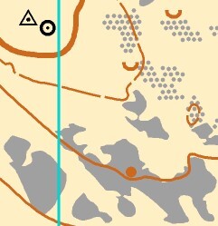
IOF ISOM2017 symbols, except:
- Bare rock symbol (solid grey) is used for continuous limestone pavement
- Grey stipple is used for broken limestone pavement
- Black triangle with dot is used for trig pillars
Examples of these are included in the map extract: Moughton Terrain
The black stipple stony ground symbol is used, in varying densities, for scree and in other instances where the rock is significant, but not recognisable as broken limestone pavement.
Terrain Description
Moughton & Sulber lie on the lower south-eastern slopes of Ingleborough, rising to 427m. Neither area has been used before for orienteering and they offer some of the best terrain in the Yorkshire Dales. The 3 Peaks path between Horton in Ribblesdale and Ingleborough crosses the area, as does the Pennine Bridleway, and Sulber is part of the Ingleborough Nature Reserve.
Both are open areas with a mix of limestone pavement and series of scars separated by flatter grassy terraces. The rough open land varies from fast going on the ridges to slow run in the generally more tussocky valleys. Areas shown as broken ground or with multiple depressions are often heathery and very slow.
The limestone crags are crossable with care except for those shown as impassable, but often have areas of boulders, rocks or scree below which are tough going.
The limestone pavement has fairly distinct boundaries and is walk/slow run when dry but can be very slippery if wet. Areas mapped as broken limestone are more fragmented and their edges are not distinct. They have been mapped to show the general runnability but should not be relied on for fine navigation. Throughout the area limestone is never far from the surface.
Moughton (visited by all courses using the Far Start) has no internal walls and very few paths or other line features. You can expect long challenging legs with interesting route choices interspersed with short legs in the detailed technical areas. There are two bracken-filled valleys (shown with the undergrowth symbol) which will be slow going in September, but courses are planned with the option to avoid these areas. Low-growing juniper scrub is widespread on the northern slopes of Moughton; much of it shows signs of damage by the Phytophthora fungus. It is shown on the map only where patches of scrub are big enough to hinder progress, using the green “Forest - walk” symbol.
Some of the limestone pavement has numerous narrow slabs of rock (thought to be prehistoric) inserted vertically into the grikes. These have not been mapped but the larger ones are quite prominent from a distance.
Courses from the Near Start are entirely on Sulber, and the other courses all finish here too. It is generally less physically & technically challenging than Moughton, with some paths and ruined walls, but the mix of rock and contour features still provides interesting terrain and scope for getting lost.
There are numerous cairns on both areas - walkers’ ones along the main path up Ingleborough and larger prehistoric ones which litter the prominent hilltops and spurs. There are also many burial cairns – those on Sulber are now reduced to low earth mounds and these have been mapped as knolls. On Moughton they remain as small rocky mounds which are mapped as cairns. You may encounter the remains of prehistoric settlements - low earthbanks and very ruined walls showing the outlines of buildings and enclosures.
Gates
Gates on the main path are easy to open and close and must be kept shut. Any other gates will be secured so they are open wide enough to allow runners but not cattle through. Please take care to leave them as you find them. One has a single strand of barbed wire above it which will be covered and taped, but it will only affect you if you are over 6’ 3”
Cattle
There are cattle on the area but they are used to walkers and runners and are unlikely to take any notice of you.
Footbath
At the gates leading from Moughton onto Sulber there will be a foot bath which you are required by Natural England to use to help prevent the spread of Phytophthora from the juniper.
Out of Bounds areas
There are several "wet flushes" in the area which are ecologically sensitive and must not be crossed. Those close to courses are shown as OOB on the map and will be marked on the ground with red & white tapes. Please do not run through them as it may jeopardize the future use of the area.
Acknowledgements
We are grateful to the following for permissions to stage this event, and for their assistance and co-operation.
Farrer Estate
Natural England - Andrew Hinde
Horton Playing Fields Association - Richard Pattinson
Dog restrictions
Dogs are allowed in the assembly area but under close control please, and please clear up any mess.
Similarly dogs are allowed on the path to the near start and finish, but must be on a short lead as you will pass through fields with sheep. There may be some cattle on the Sulber part of the area, part of the Ingleborough National Nature Reserve. This includes the areas around the Near Start and Finish.
Dogs are not allowed on the Courses.
Contacts / Officials
Organiser : Peter Haines 07553 386253 hainesilkleyATyahoo.co.uk
Planners: Andy Hobson, Anne and Richard Wilson
Controller: Nick Howlett (LOC)
Assistant Organiser: Chris Burden