MapRun
App that displays Maps on phone and uses GPS to track and time you.
Virtual orienteering using your phone to complete a course of virtual checkpoints spread throughout an area such as a town, park or forest.
The courses have no infrastructure on the ground and are open 24/7 so you can fit in a course any time you want! No reason to stop the fun of running, exploring and orienteering.
What is MapRun?
MapRun offers a new dimension to running – getting you out and about and exploring our different urban areas and parks.
Missing your Orienteering events? missing your Park Run? Want to liven up a training run?
Rather than running the same route every day, challenge yourself to visit any number of checkpoint locations and return back to the starting point as quickly as you can! This free smartphone app will automatically record each site you visit, and at the end will upload your result so you can compare your performance against everyone else. Come back again and try a different route next time to optimise your time! Then try our other courses which we aim to quickly add to.
MapRun has no infrastructure on the ground – all you need is a smartphone and preferably a print of the map; it’s a time trial rather than a race so you can run any course, any time you want, as many times as you want!
How does it work?
MapRun is a run where you decide the route! Most of our MapRun courses are score format
- You have XX minutes, and a map with YY checkpoints to visit.
- Your goal: to score points by visiting checkpoints. Score as many points as you can and get back to the start within the time limit
- You can visit whichever checkpoints you like, in any order, via any (legal!) route.
- If you go over the time limit, you’ll start to amass penalties – make sure you’re back at the finish in time!
Speed is an advantage, but the fastest runner won’t necessarily come out on top. It’ll take smart planning to find the shortest route worth the most points.
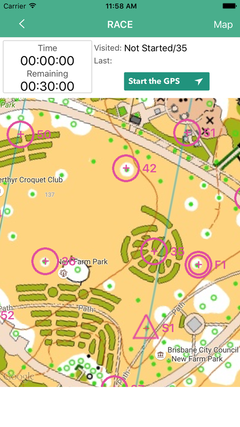
MapRun main race screen
Getting Started
The first thing you need to do to get going is to download and install the Maprun app from your App Store. Note that there is a new version of MapRun now available, called MapRun, make sure that you install that rather than the older Maprun6 or MapRunF apps.
Or you can search for the app called MapRun, by FNE Enterprises.
Once installed, you need to enter a small amount of personal information - name and so on – this is to be able to identify yourself in the results system.
You should also check that your phone is correctly set up for maprun.
See our phone settings tips page.Map Run Phone Setting Tips
Print off a copy of the pdf map of the Map run you are going to do from the Airienteers or Find Your Way website.
You are then ready for your first MapRun course.
- Start the app.
- Use the QR Link from our course webpage if there is one otherwise;
- Tap Select Event. You'll need to scroll down to the UK folder, and then into Aire Valley. or Find Your Way>Aire Valley
- Select the course you want to run. The course names tie into the location and pdf copy of the map as described on the Permanent Courses section of this website.
- Wait for the course and map files to download, and then tap Go to Start.
The course is now live,and will start logging your track and time when you pass through the Start. Before you pass through and record the Start, your location and track are shown on the screen so that you can see if your GPS is working. These will disappear as you start.
Also, in the footer of the screen is shown: Current GPS accuracy.
Most of our courses are enabled fro you to Start Anywhere, if so the marked start/ finish becomes and extra available marker. You must finish where you start though.
You need to run or walk through the start to trigger the course timer, your phone will beep at you. At each Checkpoint, every time you get close enough (usually 5-10metres), you will hear a beep from your phone to confirm the system has registered. Remember to listen out for the beep as you are nearing the checkpoint. (If it doesn't sound when you expect to and you are sure your in the right place you can also check whether it has registered by looking at the map on your phone an seeing if the control has changed from purple to green.) Also remember you must pass through the finish to stop the timer.
As you finish your results should be uploaded automatically to the Maprun server. If they are, you will see a prompt on the screen to allow you optionally to upload to Strava. If not, you should see a prompt simply to upload results. Your results also show Split times between each checkpoint.
Finally, you can compare your results with others that have been on the same course and view the route you took.
You can find quick links along with full instructions on the MapRunners website http://maprunners.weebly.com/
Please ensure you read and agree with the MapRun user agreement. Map Run User Agreement
MapRun has been developed and is maintained by Peter Effeney with the support of Orienteering Australia.In the UK he is supported by Pat Macleod from North Gloucester O C. Many thanks to Peter and Pat for their assistance in getting us up and running!
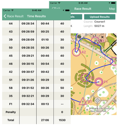
MapRun Results Screen
Available MapRun Courses
There are 2 Terrain Permanent Courses at Ilkley Moor and Danefield, Otley.
Parkland Courses in the Find Your Way folder are Armley/Gotts Park (also traditional permanent course), Bramley Park, and Nunroyd Park.
Different Open Map Urban Courses at Bramhope, Burley in Wharfedale, Cookridge, Crossgates, Farsley, Garforth, Headingley, Idle, Menston, Rawdon, and Shipley.
The full information you require on each course and the paper map download is in our Permanent Courses Section:
Available Permanent Orienteering Courses
Tips and Tricks
You’ll very quickly get the hang of the technology. Here are a few tips for getting the best out of your run, and maximising your points haul on a score course….
- Knowing how far you can run in time limit minutes and planning a route that is shorter than this!
- Picking a good order to visit checkpoints that is efficient and avoids running back past locations you’ve already been to.
- Counting how many contours your route will cross – these mean going up or downhill and the direction of slope may not be immediately obvious from the map.
- Spotting the fastest (normally the shortest) route between individual checkpoints.
- Looking where checkpoints are concentrated close together.
All of these will get easier with experience, and you may find you score better the second time you run a course!
What to wear / bring / Safety
While MapRun is designed for you to be able to navigate and complete the course just utilising the apps map on your phone navigating using the map on the phone screen can be a bit tricky, especially when running.
Particularly for our type of score events seeing the whole context is also difficult on the phone screen. Therefore, we strongly advise that you print off and carry a paper copy of the map which is A4 size. The pdf’s are on the individual event/venue page.
If you are only going to use the paper map while running and in effect are using the phone to record your time ,track and sound when passing through the checkpoints it is best to stow it after you have pressed the “go to start” button and seen that GPS is active by red position dot showing on phone.
Bring something to carry your phone in. A specialist armband is best but a bumbag, jacket pocket etc works ok too.
Another reason to take a paper copy of the map is safety as you will be able to find your way back if your phone battery were to run out.
As many MapRun's have a time limit and penalty points are automatically calculated after the limit a watch is definitely handy.
Although the navigation involved is quite straightforward, a simple compass can still be useful to help point you in the right direction but many do without.
MapRun's usually take place in urban environments around residential streets and local parks, therefore specialist clothing is not required.
Your usual running gear will be fine, whatever you feel comfortable in but we recommend Hi Viz/ bright clothing.
Safety
MapRun takes place on streets footpaths and open public areas. You are responsible for your own safety, and runners must take particular care when crossing roads. In some case roads and paths may be marked out of bounds, by means of red/purple crosses, and you may not run on or cross these. Please also take care when running down narrow lanes, or around corners, to avoid collisions with pedestrians. Be polite to others in the area.
British Orienteering have confirmed that their insurance policy does not cover individuals who are out for a run on their own rather than participating at a registered organised event. Therefore anyone undertaking MapRun is doing so in their own time, run at their own risk and Airienteers Orienteering Club and British Orienteering take no responsibility for any damage or injury whilst participating.